


Special Weather Statement for Far North Georgia
Community January 5, 2022
Moderate to heavy rain expected through Thursday
Community October 6, 2021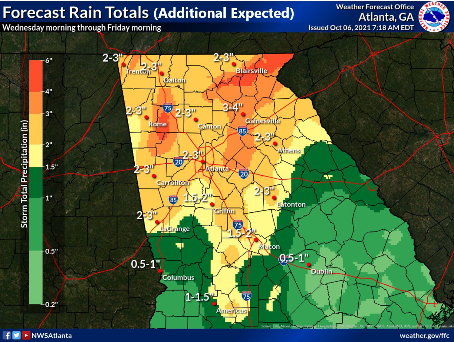
HIAWASSEE, Ga – Towns County remains under a flash flood watch until October 7 at 8 p.m.
Much of north Georgia is under the watch including all surrounding counties.
The National Weather Service Office out of Peachtree City (NWS) cautioned residents to pay attention to later forecasts in case they need to take action.
In a longer weather report, NWS stated:
“Rounds of moderate to heavy rain with embedded thunderstorms are expected through Thursday evening. Widespread additional rainfall totals of one to three inches are forecast across the watch area. Locally higher amounts will be possible, especially across north and northeast Georgia. The potential for localized flash flooding and quick rises on rivers and creeks will continue through Thursday, given the wet ground and above normal streamflows across the watch area. Several rivers and creeks have already responded to previous heavy rainfall.”
The weather appears to improve by the weekend.
Meet Luke Dockery: Towns County’s youngest weatherman
Featured Stories December 19, 2019
YOUNG HARRIS, Ga. – Luke Dockery, a Towns County homeschool student, enjoys weather forecasting, and his passion for the useful hobby is noteworthy. The 15-year-old amateur meteorologist maintains a devout presence on social media, informing the public of weather-related events on a dedicated basis. Whether there be rain, freezing temperatures, or winter precipitation in-store, the jovial teen is always in the know.
“I became interested in the weather back in 2013,” Dockery told FYN. “My dad had a weather radio, and bad weather was moving through. I was so amused by how they worked and alerted. After all the bad weather moved through, I looked them up on how they work and it was so interesting. I decided to start getting some, and I got my first one on Christmas 2015. I was so happy. I got more interested in the weather so I started buying more and collecting them. My collection grew as the years passed.”

Dockery owns and operates an impressive collection of NOAA weather radios, 33 in total.
Dockery became an official National Weather Service (NWS) storm spotter on Oct. 18 following the completion of a SKYWARN training course held at the E-911 center in Young Harris.
The SKYWARN class was designed to prepare participants to identify and report severe weather events, alerting the NWS of meteorological ground conditions and resulting damage to the area. Students, which consisted of citizens and first responders, were provided information on how to determine and monitor the structure of approaching storms, and what to report to the NWS in the event of severe weather.
Each Wednesday at 11:30 am, Dockery conducts the required weekly tests on his vast collection of NOAA weather radios. The 10th-grade homeschooler shares his meteorological knowledge on multiple social media pages including his own, Georgia and Western North Carolina Weather Updates.
FetchYourNews.com attracts over 300,000 page views and 3.5 million impressions per month with a 60,000 Facebook page reach. Approximately 15,000 viewers per week visit FYNTV.com
If you would like to follow up-to-date local events in any of our 12 counties of coverage, please visit us at FetchYourNews.com
Towns County EMA encourages community to attend SKYWARN course
News October 8, 2019
YOUNG HARRIS, Ga. – Towns County Emergency Management Agency (EMA) encourages citizens and first responders with an interest in weather to attend an Oct. 18 SKYWARN training session in Young Harris. The course will cover the importance of storm spotters, the basics of thunderstorms, the relationship between the National Weather Service (NWS) and EMA with the media, basic radar interpretation, identification of potential severe storm features, information on reporting weather observations, and storm spotter safety tips.
SKYWARN storm spotters are an important group of volunteers that report severe weather, winter weather, and resulting damage to the NWS, the organization’s website explains. These reports aid the weather service in accomplishing its mission of “protection of life and property” by providing forecasters essential information of what is occurring at ground level. SKYWARN spotters receive training from the NWS, learning weather safety, storm structure, and reportable criteria. The course is typically held in conjunction with local government or area SKYWARN groups.
“Towns County has been certified as StormReady for several years,” Towns County EMA Director Brandon Walls said. “The recertification cycle is every four years, the last being in 2016.” In order to be recognized as StormReady, a county must meet criteria jointly established between the NWS and state-local emergency management officials. Approximately 230,000 citizens have participated in the SKYWARN program nationwide.
The SKYWARN course is scheduled Friday, Oct. 18, at the Towns County Emergency Operations Center at 1100 Jack Dayton Circle in Young Harris, GA, at 6 pm.
For additional information, contact Towns County EMA at [email protected]
Towns County citizens, first responders trained as NWS storm spotters
News October 19, 2019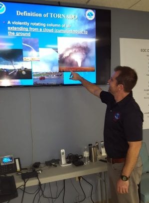
YOUNG HARRIS, Ga. – The National Weather Service (NWS), in cooperation with Towns County Emergency Management Agency (EMA), held a SKYWARN storm spotter class Oct. 18 at the Towns County Emergency Operations Center. Towns County citizens, along with first responders from Hiawassee Police Department, Towns County Fire and Rescue, and Towns County Emergency Medical Services, attended the severe weather seminar. The course was conducted by Peachtree City NWS meteorologist Dave Nadler.

An instructional SKYWARN slide shown during the presentation.
The SKYWARN class was designed to prepare participants to identify and report severe weather events, alerting the NWS of meteorological ground conditions and resulting damage to the area. Attendees were supplied with information on how to determine and monitor the structure of approaching storms, and what to report to the NWS in the event of severe weather. Safety instructions were included in the course.
Towns County became a StormReady community approximately 12 years ago, and re-certification is required by the NWS every four years.
Towns County EMA urged the community to sign-up for the CodeRED Weather Warning system, a computer-operated program that alerts residents of foul weather-related conditions. CodeRED Weather Warning is a unique service that automatically notifies citizens in the path of severe weather, moments after a warning has been issued by the NWS. CodeRED alerts are available at no cost.

Luke Dockery, a local weather enthusiast who completed the SKYWARN training.
The service delivers notifications to landlines and cell phones, emails, texts, social media, and/or mobile alerts. Residents and visitors will receive enhanced public safety alerts no matter where they are located via the CodeRED Mobile Alert app – a free public safety app for both Android and iPhone users. The CodeRED Mobile Alert app delivers community and emergency alerts to individuals targeted within an impacted geographical area so that citizens receive timely notifications when traveling away from home.
Click here to sign-up for CodeRED alerts
Feature Image: NWS meteorologist Dave Nadler leading the SKYWARN class.
Archive:
How low can it go? Towns County braces for single digit temperatures
Business January 2, 2018
HIAWASSEE, Ga. – The new year is off to a frigid start throughout most of the nation, and Towns County hasn’t escaped winter’s wrath. As overnight temperatures plummeted, area creeks awoke to frosty conditions, while local ponds slumbered beneath glazes of ice, on the morning of Tuesday, Jan. 2, 2018.
The worst of the weather is yet to come with lows expected to dip into the single-digit range before the weekend arrives. Wind speeds are predicted to reach 16 mph, causing the arctic air to feel all the more bitter, according to the Weather Channel.
Towns County Emergency Management Agency (EMA) advises motorists to use caution while traveling, especially after dark, to avoid accidents due to the potential formation of “black ice” on roadways. Black ice is a thin coating of frozen precipitation which clings to pavement, nearly invisible to the naked eye, and results in dangerous driving conditions. Ready Georgia, a service of the Georgia Emergency Management Agency, provides valuable preparedness information on winter travel.
“We always want to remind drivers to be alert, use caution, and reduce speed any time the temperature is below freezing,” Towns County EMA Assistant Director Brandon Walls told FetchYourNews. “Be especially cautious during hours of darkness, and please, do not attempt to drive before your windows are completely clear of ice and snow.”
Freezing temperatures can also damage waterlines in homes and businesses if precautions are not taken.
State Farm Insurance offers these tips to protect homes against frozen pipes, ice dams, and other water-related losses:
- Insulate exposed water pipes, such as those in crawl spaces or that run along outside walls, floors and ceilings;
- Use heat tape or thermostatically controlled heat cables to wrap pipes;
- Seal cracks and gaps, which could bring in cold air with insulation or caulk. Check around dryer venting, electrical wiring, doors, and windows nearest to exposed pipes;
- Disconnect exterior water hoses and drain pipes leading outdoors. If possible, use an indoor water shutoff valve to ensure water service to exterior locations is disconnected; and
- Keep your thermostat set above 55 degrees, especially if you will be away from your house for an extended period. Ask someone you trust to monitor your house daily to prevent freezing.
Remember to bring pets indoors or provide warm, adequate shelter during the brutal, wintry nights.
Count on FetchYourNews to monitor weather conditions in Towns and surrounding areas of coverage.
(Featured Image: Owl Creek, located west of Highway 75 south, in Towns County)
Fetch Your News is a hyper local news outlet that attracts more than 300,000 page views and 3.5 million impressions per month in Dawson, Lumpkin, White, Fannin, Gilmer, Pickens, Union, Towns and Murray counties as well as Cherokee County in N.C. – FYNTV attracts approximately 15,000 viewers per week and reaches between 15,000 to 60,000 per week on our Facebook page. – For the most effective, least expensive local advertising, call 706-276-6397 or email us at [email protected]
*UPDATED* School Closings Due to Severe Weather Conditions
News September 11, 2017
- Union County Schools will be CLOSED Monday, September 11th and Tuesday, September 12th due to Gov. Nathan Deal declaring a state of emergency for all 159 counties in Georgia. Please continue to monitor here for further updates.
- Fannin County Schools will be closed for students and all personnel on Monday, September 11 and Tuesday, September 12, for students, as well as all faculty and staff, except for 12-month personnel, district directors, and principals. As long as it is safe to do so, all 12-month personnel, as well as district directors and principals, should anticipate reporting by 9:00 a.m. on September 12. These personnel should note, though, that this expectation may be revised, depending on the weather conditions overnight; nonetheless, if you ever believe it is unsafe to report, please notify your immediate supervisor. In addition, the Board of Education work session meeting that was scheduled for 8:00 a.m. on Tuesday, September 12, has been cancelled. Please continue to stay safe!
- Pickens County Schools closed Monday, September 11th – TWELVE MONTH EMPLOYEES REPORT AT NORMAL TIME. Schools will also be closed on Tuesday, September 12. Twelve month employees will be contacted late Monday as to whether they will be required to come to work on Tuesday. All school activities, including athletic events and after-school programs, will be canceled.
- Gilmer County Schools will be closed Monday, September 11th and Sepember 12th due to Hurricane Irma. We have made this decision after consultation with local emergency management authorities and careful consideration of safety factors, such as the probability of severe winds especially at higher elevations, debris, dangerous road conditions and downed power lines left in its wake. Only 12 month staff should report if safe to do so.
- Dawson County Schools will be closed on Monday, September 11, and Tuesday, September 12, 2017. Twelve month employees will operate on a 2 hour delay.
- Lumpkin County Schools closed due to the weather forecast for our area, Lumpkin County Schools will be closed on Monday, September 11, and Tuesday, September 12, 2017. The anticipated high winds pose a significant threat to our students and staff. We understand that weather predictions are not always accurate, but we cannot ignore the potentially dangerous situation that this storm poses. Our number one priority is to keep our students and staff safe! Wednesday will still be a early release day as planned so that teachers will be available for parent conferences. 12 month employees should report if it is safe to do so.
- Towns County Schools closed Monday, September 11th and Tuesday, September 12th for all students. All employees should report at 10:00 AM on Tuesday, September 12th if safe to do so.
- White County Schools due to the severe weather forecast, White County Schools are closed for students and staff Monday, September 11, and Tuesday, September 12, 2017. Please be safe!
- Murray County Schools closed Monday September 11 and Tuesday September 12, due to the possible impact of Hurricane Irma. We have made this decision after consultation with local emergency management authorities and careful consideration of safety factors, such as the probability of severe winds, debris, dangerous road conditions, and downed power lines. We understand that weather predictions are often incorrect, but the size of this storm cannot be ignored. It is our hope that Murray County is spared from any of this storm’s impact, but we will always choose to error on the side of caution. All events planned for Monday and Tuesday evenings are also cancelled. This includes the September 11 MCPS Board meeting. This meeting will be rescheduled for Thursday, September 14 at 6:15 p.m. All maintenance, grounds crew, and transportation employees will meet at the transportation office.
Area responders urge residents to prepare for rounds of rain
News February 17, 2019HIAWASSEE, Ga. – Meteorologists are forecasting a heavy amount of rainfall to descend on the north Georgia and western North Carolina mountains throughout the coming week, warning that possible flash flooding may occur in prone locations. According to the National Weather Service, a total of 5 to 7 inches of rain is expected in the region with the potential of 10 inches of localized precipitation possible.

North Carolina forecast by WNC Weather
Area first responders urge residents to remain aware of current conditions as rainfall amounts accumulate.
Towns County Emergency Management Agency encourages citizens to register with the CodeRED call-text alert system, an automated program that notifies residents of impending concern.
“We are aware of the potential of this storm impact over the next several days,” Towns County EMA Director Rickey Mathis explained to FYN this morning. “I have spoken to the Area 1 GEMA field coordinator as well as the chapter chairman of the Red Cross. If needed, we will open a comfort station for those that may need to evacuate. The situation that is most concerning is a heavy rain 1-2 inches in a short period of time. With the ground saturation, it just runs off. Subscribing to the CodeRED alert system is a great way to get local information, and a great way for us to quickly alert the citizens as well as social media and FYN.”
Residents can subscribe for CodeRED alerts at http://www.townscountyga.org/emergency-alert-system.html
Hiwassee Dam Fire Department is ready should conditions warrant an emergency response. “Our swift water response team is prepared. If you live in flood prone areas, stay alert,” the Murphy, NC department advised. “Monitor the streams as well as NOAA radio. Be prepared to evacuate. The forecast is still not set in stone, but we have seen predictions for anywhere from 6 to 12 inches of rain through Friday. The ground is saturated and the streams are already above normal flow.”
Emergency crews in Towns County, GA, Clay County, NC, and surrounding areas are additionally trained in swift water rescue.
Follow FYN for weather-related updates in our area of coverage.
Fetch Your News is a local now-news outlet, attracting more than 300,000 page views and 3.5 million impressions per month in Towns, Dawson, Lumpkin, White, Fannin, Gilmer, Pickens, Union, and Murray counties, as well as Clay and Cherokee County in N.C. – FYNTV attracts approximately 15,000 viewers per week, reaching between 15,000 to 60,000 on our Facebook page.
Annual rainfall 140 percent above average, says TVA
News January 4, 2019
HIAWASSEE, Ga. – Rainfall amounts were 140 percent above normal in 2018, with run-off amounts 200 percent higher than average in the Tennessee Valley Authority (TVA) River Management area.
TVA manages the 652 mile long Tennessee River and its numerous tributaries, incorporating a series of 49 dams to meet vital public needs in six key areas: navigation, flood damage reduction, power production, water quality, water supply, and recreation.

Tennessee River Basin
“For the week before Christmas, rainfall averaged two inches in the eastern Valley and 1.4 inches in the western Valley,” said James Everett , the senior manager for TVA’s River Forecast Center, “We began spilling and sluicing at several locations the day after Christmas to increase flows and increase flood storage capacity, and that will likely continue into the new year.”
Everett explained that TVA is spilling or sluicing this week through the gates at South Holston, Wilbur, Cherokee, Douglas, Norris, Fontana, Apalachia, Ocoee 3, Great Falls, Fort Loudoun, Watts Bar, Chickamunga, Nickajack, Guntersville,Wheeler, Wilson, Pickwick, and Kentucky reservoirs.
Everett said that most dams along the main stem of the Tennessee River have been in spill operation since mid-October and will likely be spilling well into 2019.
Due to Potential Winter Weather, Gov. Kemp Closes State Offices
Announcements January 28, 2019

|

Weekend storms cause widespread power outages
News June 25, 2018
HIAWASSEE, Ga. – Strong, sudden storms swept through northern Georgia and western North Carolina over the weekend, leaving approximately ten thousand Blue Mountain Electric Membership Corporation (BRMEMC) customers temporarily without electricity. Strong winds downed trees and power lines, and in some instances, severed the poles themselves. On the evening of Sunday, June 24, a reported 125 customers were without electricity in Towns County. The following morning, BRMEMC announced that 28 outages remained, affecting 503 customers, mainly in Cherokee County, North Carolina. As of noon on Monday, June 25, the amount of affected customers was reduced to 187.
Saturday and Sunday’s storms arrived in near unison, with CodeRED weather warnings dispatched to Towns County residents shortly before 3:30 p.m. both days. An emergency email alert warned of possible 60 mile-per-hour winds and quarter-size hail. In the aftermath, an overturned boat dock was reported on Lake Chatuge, and tree debris littered roadways throughout the county. While the weekend storms generated more wind than lightning, each weather event differs.
Summer storms in the mountains can trigger flash flooding, lightning, hail, and other dangers, with storm frequency increasing as the warmer months progress. “If you hear thunder, lightning is close enough to pose an immediate threat,” said Federal Emergency Management Agency (FEMA) Region V Acting Administrator Janet M. Odeshoo, “Seek shelter as quickly as possible. There is no place outside that is safe when a thunderstorm is in the area.”
Sheltering in structures such as homes, offices, and schools is advised. FEMA cautions to remain away from windows, doors, and any unit that conducts electricity, such as landline phones, wiring, plumbing, and anything connected to such. If caught outdoors during severe weather, never seek shelter under a tree, tower, or electrical pole as lightning tends to strike taller objects. Evacuate from elevated areas such as hills or peaks, and move away from bodies of water. Avoid objects that conduct electricity, including wires and fences. Never lie flat on the ground. Lightning can strike from up to 10 miles away. If thunder is heard, danger is near.
Strong wind gusts can down trees and power lines, and cause unsecured objects to project, causing damage. Having emergency supply kits on hand is advised in the event of a substantial time lapse between the outage and restored power. A list of recommended items can be found at ready,gov
Feature Photo Credit: BRMEMC
Flash Flood Watch for North Georgia
News June 23, 2017
This information is from the National Weather Service. To see the full NWS Radar Image for Georgia please follow the link.
The remnants of Tropical Storm Cindy will push east through the weekend. Expect the moisture associated with TS Cindy to interact with a boundary that will move south across the region through Saturday night. Given the already saturated soils and plentiful moisture expected with this front, we may see more flooding issues, especially across north GA.
Over the past 24 hours, we have observed 1-3 inches of rainfall, mainly north of I-20. This will be the main area of concern in terms of flooding potential.
WHAT:
Flash Flood Watch is in effect across north GA (along and north of I-20).

WHEN:
From 2 PM this afternoon through 8 PM Saturday evening.
IMPACTS:
An additional 1-2 inches with locally higher amounts is possible, potentially within the metro Atlanta area and points north and west. This may lead to flooding in low lying and flood prone areas, especially in urban areas and along Interstate 20. In addition, creeks, streams and rivers may overflow their banks.

Rain expected to produce possible flooding through New Years
News December 27, 2018
HIAWASSEE, Ga. – The National Weather Service issued a Flash Flood Watch which will take effect this evening, Thursday, Dec. 27, with a Wind Advisory currently in place throughout FYN’s areas of coverage.
Between Thursday evening through Saturday morning, light rain will move into the state Thursday, becoming moderate to heavy across most of north and central Georgia Thursday night. The heavy rain will persist into Friday before tapering off Friday night. Total rainfall of 1.5 to 3 inches is expected through Saturday morning with isolated higher amounts likely.
A second round of precipitation is expected to develop on Saturday, with an additional 1-2 inches of rain possible through New Year’s Eve.
A Wind Advisory is in effect for portions of north Georgia through 7 a.m. Friday morning, with sustained winds 10 to 20 mph, with gusts to 40 mph possible. The strongest gusts are expected across the higher elevations and ridgetops. With already saturated soils, strong winds could down trees and power lines.
Soil conditions remain highly moist and river levels remain elevated across the area. Even a relatively small amount of rainfall will produce significant runoff and flooding of creeks and rivers. Once the rain ends, high water could persist for several days after.
Hurricane Irma prompts school closings in Georgia
News September 10, 2017
 * Union County Schools will be CLOSED Monday, September 11th, 2017 due to Gov. Nathan Deal declaring a state of emergency for all 159 counties in Georgia. Please continue to monitor here for further updates.
- Fannin County Schools will be closed for students and all personnel on Monday, September 11.A great deal of consideration has been given to this decision. Governor Deal has us under a State of Emergency. Severe weather conditions, such as severe winds (especially at higher elevations), debris, dangerous road conditions, and downed power lines are all possible for our area beginning tomorrow(Monday) morning.Weather predictions are not always accurate, but this storm is massive and cannot be ignored. It is my hope that our community is spared from this, but it is better to err on the side of caution when safety is in question. Please stay safe!
- Pickens County Schools closed Jasper, Georgia — Due to inclement weather conditions,the Pickens County School District will be closed tomorrow, Monday, September 11th – TWELVE MONTH EMPLOYEES REPORT AT NORMAL TIME. Schools will also be closed on Tuesday, September 12. Twelve month employess will be contacted late Monday as to whether they will be required to come to work on Tuesday. All school activities, including athletic events and after-school programs, will be canceled. Information will be posted on the Pickens County School District website at www.pickenscountyschools.org, the Infinite Campus parent portal, district and school websites and social media sites, and sent to local media.
* Gilmer County Schools closed Release from Gilmer County School School Closed – Monday, September 11, 2017Gilmer County Schools will be closed Monday September 11 due to Hurricane Irma. We have made this decision after consultation with local emergency management authorities and careful consideration of safety factors, such as the probability of severe winds especially at higher elevations, debris, dangerous road conditions and downed power lines left in its wake. We understand that weather predictions are not always accurate, but this storm is massive and cannot be ignored. It is our hope that our community is spared from the force of this storm, but we will always choose to err on the side of caution when our students’ safety is in question.
* Dawson County Schools Closed Based on information from the NWS, Dawson County Schools will be closed on Monday, September 11, 2017. Twelve month employees report.
* Lumpkin County Schools Closed Due to the weather forecast for our area, Lumpkin County Schools will be closed on Monday, September 11, 2017. The anticipated high winds pose a significant threat to our students and staff. We understand that weather predictions are not always accurate, but we cannot ignore the potentially dangerous situation that this storm poses. Our number one priority is to keep our students and staff safe! Decisions for future closings will be made as more information becomes available. Thank you for supporting Lumpkin County Schools!
* Towns County Schools will be closed Monday for all students and staff. A decision about Tuesday will be made tomorrow afternoon.
* White County Schools Closed Due to the severe weather forecast, White County Schools are closed for students and staff Monday, September 11, 2017. Please be safe!
* Murray County Schools Closed Murray County Schools will be closed Monday September 11 and Tuesday September 12, due to the possible impact of Hurricane Irma. We have made this decision after consultation with local emergency management authorities and careful consideration of safety factors, such as the probability of severe winds, debris, dangerous road conditions, and downed power lines. We understand that weather predictions are often incorrect, but the size of this storm cannot be ignored. It is our hope that Murray County is spared from any of this storm’s impact, but we will always choose to error on the side of caution. All events planned for Monday and Tuesday evenings are also cancelled. This includes the September 11 MCPS Board meeting. This meeting will be rescheduled for Thursday, September 14 at 6:15 p.m. All maintenance, grounds crew, and transportation employees will meet at the transportation office.
URGENT – RED FLAG WARNING
News November 4, 2016URGENT – RED FLAG WARNING
FIRE WEATHER MESSAGE
NATIONAL WEATHER SERVICE
The National Weather Service in Peachtree City has issued a Red Flag Warning for areas mainly along and north of a Columbus to Macon to Washington line… Which is in effect from 10 am to 7 pm EDT Friday. Winds 15 to 20 mph gusting 25 to 30 mph with greater wind speeds likely in the higher elevations of North Georgia.
Any ongoing wildfires or additional fires that might develop will likely spread rapidly. Outdoor burning of any kind is strongly discouraged and already banned in most locations. Fire danger conditions also exists for areas south of the red flag warning area and outdoor burning is not recommended there. This warning includes the Chattahoochee and Oconee National Forests.
A RED FLAG WARNING means that critical fire weather conditions will occur within 24 hours.
DADE-WALKER-CATOOSA-WHITFIELD-MURRAY-FANNIN-GILMER-UNION-TOWNS-CHATTOOGA-GORDON-PICKENS-DAWSON-LUMPKIN-WHITE-FLOYD-BARTOW-CHEROKEE-FORSYTH-HALL-BANKS-JACKSON-MADISON-POLK-PAULDING-COBB-NORTH FULTON-GWINNETT-BARROW-CLARKE-OCONEE-OGLETHORPE-WILKES-HARALSON-CARROLL-DOUGLAS-SOUTH FULTON-DEKALB-ROCKDALE-WALTON-NEWTON-MORGAN-GREENE-TALIAFERRO-HEARD-COWETA-FAYETTE-CLAYTON-SPALDING-HENRY-BUTTS-JASPER-PUTNAM-HANCOCK-WARREN-TROUP-MERIWETHER-PIKE-UPSON-LAMAR-MONROE-JONES-BALDWIN-HARRIS-TALBOT-TAYLOR-CRAWFORD-BIBB-MUSCOGEE-CHATTAHOOCHEE-MARION
Heavy Rains Bring Flooding in North Georgia on Christmas Eve
Featured, Featured Stories, News December 24, 2015
Heavy rains and thunderstorms throughout the night caused flooding in multiple areas in North Georgia. Rains and thunderstorms were steady throughout the night and into the morning with another round expected later today, Christmas Eve 2015.
[cincopa AQFAdId_6Ccu]
Reports and photos coming in show areas in Fannin, Gilmer, and Pickens Counties where flood waters are rising. FYN has reports of roads covered in water, bridges closed or out, and other areas under water.
Authorities warn citizens to use caution and do not enter areas where you cannot tell how deep the water may be. We will bring additional information as received.